


- Lost Lake Trail takes hikers a moderately strenuous 4 miles to a horse trail and Lost Lake.
- Garnet Hill and Hellroaring Trails is a moderately strenuous, 3 to 7-mile hike with two trailheads.
- Yellowstone River Picnic Area Trail takes hikers 3.7 moderately strenuous miles and offers stunning views.
Lost Lake Trail
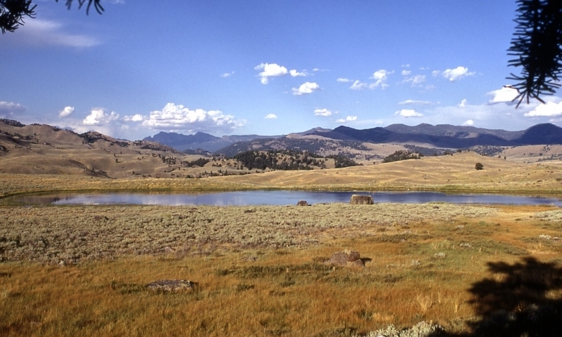
This trail offers two loop options. Beginning behind the Roosevelt Lodge, follow the steep trail up to Lost Lake. From Lost Lake, you can either head west toward the Petrified Tree Area and back to Roosevelt Lodge (Option 1) or you can head east along the toward the Roosevelt Corrals and back to Tower Fall Campground Option 2). The Petrified Forest loop is more hiker friendly as the other usually sees lots of horse traffic. Either way, you'll enjoy views of Lost Lake, waterfowl, meadows, and might catch a glimpse of beavers and black bears.
- Trailhead: Behind Roosevelt Lodge
- Distance: 4 miles round-trip
- Difficulty: Moderate
Garnet Hill
From the trailhead follow an old dirt stagecoach road past a cookout shelter, along Elk Creek, and almost to its confluence with the Yellowstone River. At this point, you can continue west over the Yellowstone to Hellroaring Creek (see below) or head east up the Yellowstone River and around Garnet Hill back to the Northeast Entrance Road. From the road walk .25 miles back to your car.
- Trailhead: Park in a large parking area just east of the service station near Tower Junction. The trail begins 50 yards north of the Tower Junction, along the Northeast Entrance Road.
- Distance: 7.5 miles round-trip
- Difficulty: Moderate
Hellroaring Trail
From the trailhead climb a steep trail to a suspension bridge that crosses the Yellowstone River. Follow the trail through a sagebrush plateau and then down to Hellroaring Creek. This trail is very popular among anglers and both rivers provide great fishing opportunities.
- Trailhead: 3.5 miles west of Tower Junction.
- Distance: 4 miles round-trip
- Difficulty: Strenuous
Yellowstone River Picnic Area Trail
From the trailhead climb steeply to the east rim of the Yellowstone River Narrows. Follow the rim until the trail veers east. At a junction you can either turn left and head back down to the road and the picnic area or head east along the Speciman Ridge Trail. The Yellowstone Rim trail offers amazing views of the river below and great opportunity to spot wildlife, especially raptors.
- Trailhead: The trail starts at the picnic area 1.25 miles northeast of Tower Junction along the Northeast Entrance Road.
- Distance: 3.7 miles round-trip
- Level of difficulty: Moderate
Slough Creek Trail
A popular trail among anglers but usually void of many visitors, the Slough Creek Trail can be as long or as short as you like. Follow a steep old wagon trail before it mellows out in the first meadow. Stop here or continue on.
- Trailhead: Near the vault toilet on the dirt road toward Slough Creek Campground
- Distance: 2 miles one way to First Meadow; 5 miles (one way to Second Meadow
- Level of difficulty: Moderately strenuous for first 1.5 miles and then easy.
Mt. Washburn Trail
This popular hike has two trailheads that switchback to the summit for expansive views of much of Yellowstone. There is a nice enclosed observation deck at the top. Hikers use the south trailhead more often while bikers and park vehicles can access the top of the mountain from the north trailhead. Bighorn sheep frequent this area and there are usually lots of wildflowers.
- Two Trailheads:
Chittenden Road Parking Area (north trailhead): 8.7 miles south of Tower Junction.
Dunraven Pass Parking Area (south trailhead): 13.6 miles south of Tower Junction. - Distance: 3.2 miles round-trip from Chittenden Road; 5 miles round-trip from Dunraven; 5.6 miles one-way if you want to run a shuttle.
- Difficulty: Strenuous


