


Why should I drive the Chief Joseph Scenic Highway?
- Learn a piece of History: Stop at Two Dots Flat, before climbing to Dead Indian Pass and read a few of the interpretive signs. You will learn about how in 1877 Chief Joseph led almost 1,000 Nez Perce tribe members over 1,000 miles of mountainous terrain to escape U.S. cavalry and the governments ploy to restrain them to a reservation. The trail that they took toward the Canadian border, Chief Joseph Scenic Highway, is now part of the Nez Perce National Historic Trail.
- Sunlight Bridge and Basin: Take in the views at the highest bridge in Wyoming, spanning the deep gorge and Sunlight Creek.
- Fishing: Fishing for trout is common along the upper quieter banks of the Clark's Fork of the Yellowstone River.
- Crandall, Wyoming: On the western edge of this route, the small community of Crandall Wyoming is more of a ranch. It is the only place to stop and by snacks and souvenirs along the way.
- Link it up with Beartooth Highway: Whichever way you come, consider making a grand loop by returning on the Beartooth Highway. You'll experience the best of both sides of the Beartooth Mountain Range.
Where does Chief Joseph Scenic Highway begin and end?
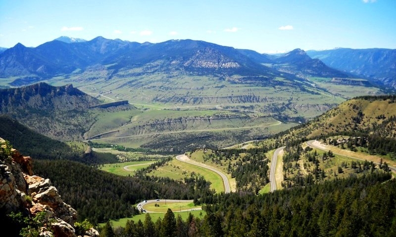
Chief Joseph Scenic Highway technically begins north of Cody, Wyoming at the intersection of Highway 296 and Highway 120. Highway 120 will access Red Lodge, Montana to the north or Cody to the south. Follow Highway 296 north over the 8,000 foot summit of Dead Indian Pass and follow seven switchbacks down to the rim of the Clark's Fork gorge. The scenic byway runs a total of 46 miles through magical Sunlight Basin, along the Clark's Fork of Yellowstone River until it intersects with Highway 212, the Beartooth Highway.
How long does it take to drive?
This highway is about 47 miles long but takes about 2 hours to drive.
When is Chief Joseph Scenic Highway accessible?
Year-round, however the road is not maintained in the winter after its junction with Beartooth Highway. You can reach this point and turn around or continue on to Cooke City via snowmobile.


